
Archaeology
Bronze Age axe found off Norway’s east coast
Archaeologists from the Norwegian Maritime Museum have discovered a Bronze Age axe off the coast of Arendal in the Skagerrak strait.
The Skagerrak Strait is a body of water that connects the North Sea to the Kattegat Sea. It is situated between the Jutland Peninsula of Denmark, the east coast of Norway, and the west coast of Sweden.
The axe was discovered at a depth of 12 metres during a routine survey for the Norwegian Coastal Administration. It was found on the seabed in an accumulation of beach-rolled flint lumps and has been identified as a hollow axe made of Bronze from 1100 BC.
Hollow axes, known as “celts”, were the dominant axe type found throughout the Nordic Bronze Age (1800-500 BC).
The hollow axe was attached to an angle-bent wooden shaft inserted into the fall opening at the end of the axe. According to the researchers, the example found in the Skagerrak strait weighs 327 grams and measures 118 millimetres in length.
How the axe ended up in the Skagerrak Strait is a matter of debate. Two prevalent theories suggest it was either from a 3,000-year-old shipwreck or is discarded ballast.
If the ballast hypothesis is correct, then the axe and flint was discarded by a ship from the sailing age on the way to Arendal’s port.
Archaeologists plan to conduct further research in the area of the discovery site to determine whether the axe is associated with a shipwreck from over 3,000-years-ago. If this hypothesis proves to be correct, then this is the first known shipwreck site from the Bronze Age in Norway.
Header Image Credit : NMM
Sources : Norwegian Maritime Museum
This content was originally published on www.heritagedaily.com – © 2023 – HeritageDaily
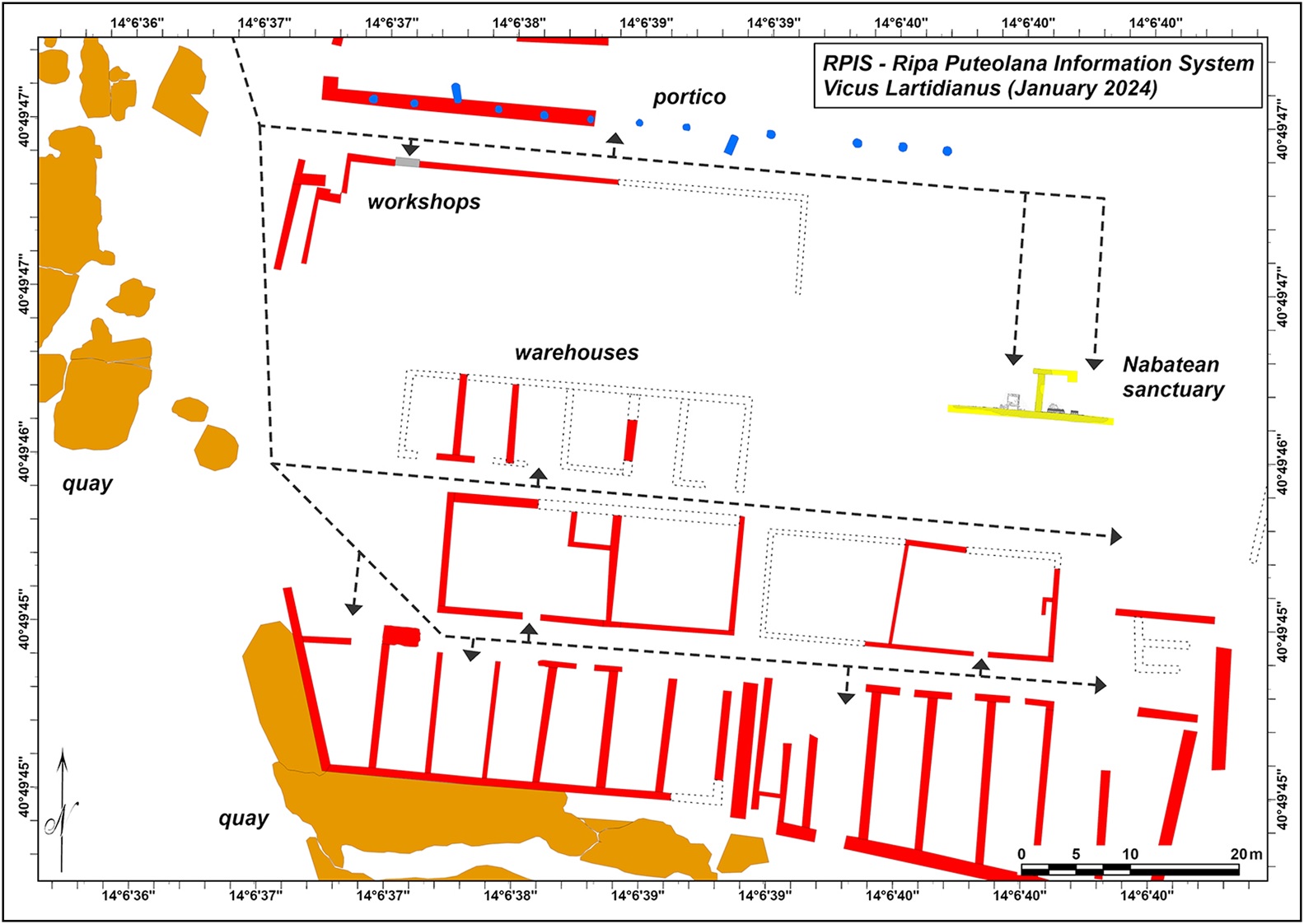
In 2023, archaeologists discovered the submerged remains of a Nabataean temple during an underwater survey of the ancient port of Puteoli, located in modern-day Pozzuoli, Italy.
Puteoli was established in the mid-6th century BC as a Greek colony called Dicaearchia. After the Roman conquest of Campania following the First Samnite War, Dicaearchia was annexed into the Roman Republic, which later founded the colony of Puteoli.
Puteoli served as one of the primary trading hubs for Rome, emerging as the great emporium of foreign trade for the Alexandrian grain ships and goods from across the Roman world.
Due to the position of Puteoli in the Phlegraean Fields, an active volcanic region, volcanic bradyseismic activity has raised and lowered the geology on the peninsula, resulting in parts of Puteoli being submerged.
The results of a year-long study, published in the journal Antiquity, has mapped and reconstructed parts of the submerged temple, the only known temple located outside of Nabataea – an allied kingdom of Rome that controlled territory from the Euphrates to the Red Sea.
The Nabataean temple and the internal routes of the vicus Lartidianus (dotted lines) at the current stage of research – Image Credit : M. Silani
Using a photogrammetric survey, the researchers have identified that the temple had a rectangular plan and two rooms with access facing north, linked to the internal routes of the vicus Lartidianus (an area designated for foreign people engaged in trade).
Within one of the rooms (designated Room A) are two altars made of white Luni marble, and a mensa with eight rectangular recesses for housing aniconic betils. In the second room (designated Room B), the southern perimeter wall has a white marble slab covering, one of which shows the inscription Dusari sacrum, meaning “consecrated to Dushara”, the chief deity of the Nabataean pantheon.
According to the study authors: “The existence of a Nabataean sanctuary within the port area confirms that there was a community from that region participating in the commercial activities of Puteoli.”
“The integration of these individuals within the local community is evident in the building techniques and materials used in the construction of the temple, and for the choice of Latin for the inscriptions to their supreme god, the lord of the mountains and the germinating force of nature, Dushara.”
Header Image Credit : M.Steanile
Sources : Antiquity | https://doi.org/10.15184/aqy.2024.107
This content was originally published on www.heritagedaily.com – © 2023 – HeritageDaily
Archaeologists from the Archaeological Museum at the University of Stavanger have discovered a Viking treasure hoard in the Hjelmeland municipality, Norway.
Excavations were in preparation for the construction of a new farm track to identify any archaeological remains in situ. The researchers discovered traces of a Viking farmstead, consisting of several structures for both the inhabitants and their animals.
Numerous domestic and agricultural objects have been unearthed, including soapstone pots, knife blades, rivets, and whetstones used for sharpening tools.
Mari Krogstad Samuelsen and Ola Tengesdal Lygre were excavating a dwelling used for housing slaves, when they identified what appeared to be twisted hedging wire at a depth of 20 centimetres.
Upon further inspection, the objects were revealed to be four heavy silver bracelets, each adorned with distinct decorative elements.
“This is definitely the biggest thing I have experienced in my career”, says archaeologist and project manager Volker Demuth from the Archaeological Museum at the University of Stavanger.
“This is a unique find, because we very rarely find such objects exactly where they were placed. As a rule, such valuable objects are discovered on fields that have been ploughed, where an object has been completely removed from its original context,” added Demuth.
According to the archaeologists, the hoard dates from around the 9th century AD and shares similarities to silver necklaces found in Hjelmeland in 1769. At that time, there were no silver mines operating in Norway, so all the silver used by the Vikings was sourced from abroad, obtained through trade, received as gifts, or taken as loot during their raiding expeditions.
Evidence of burning also indicates that the farmstead was destroyed by fire, likely during a time of conflict that required the necessity for the inhabitant’s valuables to be deposited in the ground for security.
Header Image Credit : Archaeological Museum at the University of Stavanger
Sources : Archaeological Museum at the University of Stavanger
This content was originally published on www.heritagedaily.com – © 2023 – HeritageDaily
-
 Ghosts2 years ago
Zozo: The Ouija Board Demon
-
 Space2 years ago
Scientists claim to have found the answer what existed before the Universe
-
 Ghosts2 years ago
Old Coot of Mount Greylock
-
 General3 years ago
UC San Francisco engaging in horrifying experiments, organ harvesting of live babies in the name of “science”
-
Archaeology2 years ago
New discoveries at Ekʼ Balam during conservation works