
Archaeology
New discoveries at Ekʼ Balam during conservation works
Archaeologists conducting conservation and restoration works at Ekʼ Balam have discovered several architectural and ornamental features at the Royal Acropolis.
Ekʼ Balam is a Yucatec-Maya city within the municipality of Temozón, Yucatán, Mexico. The site was occupied from the Middle Preclassic through the Postclassic, although it ceased to thrive as a major city past the Late Classic.
Ekʼ Balam consists of 45 known structures surrounded by two concentric walls. It is theorised that the city was hastily abandoned during a period of strife and great conflict, which is supported by the discovery of a fourth wall inside the city which bisects the Great Plaza, suggesting that the wall was built as a last line of defence against invasion.
After the initial discovery of Ekʼ Balam in the late 1800s by archaeologist, Désiré Charnay, only the central core of the city has been excavated which has revealed plazas, raised platforms, temples, a bath complex, a ballcourt, and the Royal Acropolis which contains the tomb of Ukit Kan Leʼk Tokʼ, an important ruler in Ekʼ Balam who ruled from AD 770 to AD 797 or 802.
Conservation works at the Royal Acropolis by the National Institute of Anthropology and History (INAH), have uncovered several pieces of decorated architecture and ornamentation on the first and third platforms.
One of the pieces of ornamentation depicts a man carved in stone, who appears subdued with his arms tied behind his back. His hair is being pulled by another figure standing to his left, suggesting that the subdued figure is likely a warrior captured in battle.
Maya polities engaged in violent warfare for political control of people and resources. Some scholars have suggested that the capture of sacrificial victims was a driving force behind warfare.
Speaking to LaJornada Maya, Arturo Chab from INAH said: “In the Maya culture, structures were perfectly designed and decorated to represent mythological beings as well as flora and fauna that was extremely important to them”.
Header Image Credit : Astrid Sanchez | Adam Jones – CC BY-SA 3.0
This content was originally published on www.heritagedaily.com – © 2023 – HeritageDaily
A study of a Roman shipwreck off the coast of Mallorca has identified a new type of amphora.
The shipwreck, known as the shipwreck of Ses Fontanelles, was discovered 65 metres from the coast of a tourist beach near Mallorca’s capital of Palma.
According to a paper published in the journal Archaeological and Anthropological Sciences, the ship dates from the 4th century and likely departed from Cartagena in southeastern Spain while navigating the trade routes of the western Mediterranean.
Archaeologists found in the hold a cargo packaged in amphorae, some of which have painted inscriptions (tituli picti) on the exterior. The inscriptions provide information such as the origin, destination, type of product, and the owner of the goods – identified as “Alunnius et Ausonius.”
The amphorae have been classified into four main group types. The most abundant is the Almagro 51c type amphorae, for which the tituli picti indicate a contents of fish sauce which derives almost exclusively from a single species: the European anchovy (Engraulis encrasicolus)
The other groups consist of the flat-bottomed amphorae, the Keay XIX type, and a new type of amphora named Ses Fontanelles I, which is larger and heavier than most other amphorae types and was used for carrying plant oil.
According to the study authors: “All the analytical data suggest that Alunnius et Ausonius prepared a trade enterprise fleeting, a merchant ship with a cargo composed mainly of fish sauce (Liquaminis flos), in Almagro 51c amphora, oil transported in Ses Fontanelles I amphorae (probably an imitation of Dressel 23 type), and grape derivates or fruits preserved in those substances in flat-bottomed amphorae.”
Header Image Credit : Arqueomallornauta – Consell de Mallorca
Sources : Cau-Ontiveros, M.Á., Bernal-Casasola, D., Pecci, A. et al. Multianalytical approach to the exceptional Late Roman shipwreck of Ses Fontanelles (Mallorca, Balearic Islands, Spain). Archaeol Anthropol Sci 16, 58 (2024). https://doi.org/10.1007/s12520-024-01952-3
This content was originally published on www.heritagedaily.com – © 2023 – HeritageDaily
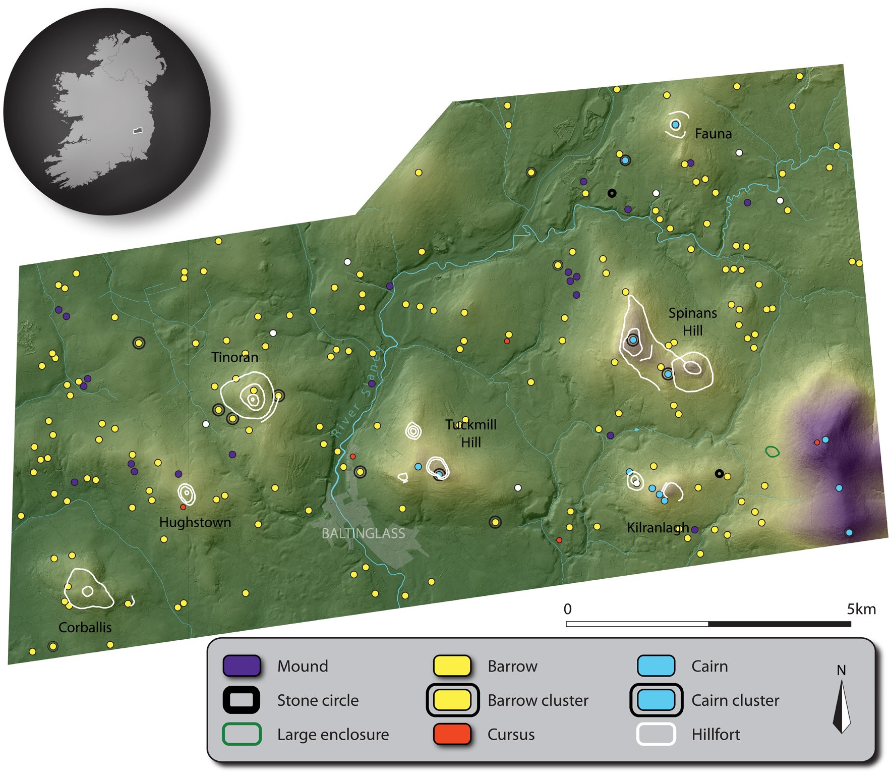
A new study published in the journal Antiquity has revealed hundreds of previously unrecorded monuments at Baltinglass in County Wicklow, Ireland.
The Baltinglass area (known as ‘Ireland’s Hillfort Capital’) has a high density of Early Neolithic and Late Bronze Age monuments, however, very little evidence has been recorded that dates from the Middle Neolithic period.
According to Dr James O’Driscoll from the University of Aberdeen, the ancient landscape around Baltinglass was incredibly important to the Early Neolithic people, however, the lack of Middle Neolithic evidence suggests that this importance was lost until the Late Bronze Age.
Using advanced LiDAR technology, archaeologists have created detailed three-dimensional models, revealing hundreds of ancient sites that that been destroyed by thousands of years of ploughing.
Image Credit : Antiquity
Light Detection and Ranging (LiDAR), is a method of remote sensing using light in the form of a pulsed laser to measure ranges (variable distances) to the Earth. The differences in the laser return times and wavelengths can be used to compile a 3-D digital map of the landscape.
The most significant discovery from the survey is a cluster of five cursus monuments, the largest example found in both Britain and Ireland. The purpose of such monuments are speculative, but some theories propose that they were used in rituals connected with ancestor veneration, that they follow astronomical alignments, or that they served as buffer zones between ceremonial and occupation landscapes.
Image Credit : Antiquity
According to the study authors: “These five cursus monuments are clearly aligned with burial monuments in the landscape, as well as the rising and setting sun during major solar events such as the solstice.”
“This may have symbolised the ascent of the dead into the heavens and their perceived rebirth, with the cursus physically setting out the final route of the dead, where they left the land of the living and joined the ancestors beyond the visible horizon,” said Dr O’Driscoll.
Header Image Credit : Antiquity
Sources : Antiquity | Exploring the Baltinglass cursus complex: routes for the dead? – James O’Driscoll. https://doi.org/10.15184/aqy.2024.39
This content was originally published on www.heritagedaily.com – © 2023 – HeritageDaily
-
 Ghosts2 years ago
Zozo: The Ouija Board Demon
-
 Space2 years ago
Scientists claim to have found the answer what existed before the Universe
-
 Ghosts2 years ago
Old Coot of Mount Greylock
-
 General3 years ago
UC San Francisco engaging in horrifying experiments, organ harvesting of live babies in the name of “science”
-
 Ghosts2 years ago
Jumbee: Demons of the Caribbean