
Archaeology
Has the burial of an Anglo-Saxon king been uncovered?
Wessex founder Cerdic’s possible final resting place has emerged more than 1,000 years after it was named in an ancient royal charter.
Cerdic is an enigmatic figure from the same era of post-Roman British history as King Arthur. This warlord carved out a realm after bloody battles in Hampshire during the sixth century.
While depicted as an Anglo Saxon invader, his reign is shrouded in mystery because his name and that of several descendants are Brittonic and many scholars believe his rule began several decades later than stated in the Anglo Saxon Chronicle.
In the charter Edward the Elder, king of the Anglo Saxons and son of Alfred the Great, granted 10 hides to Winchester Cathedral, which was roughly 11,000 acres and now largely makes up St Mary Bourne parish in Hampshire. The charter, dated to 900 AD, featured various landmarks to show the boundary of the land, including ‘Ceardices Beorg’ in Old English that translates as ‘Cerdic’s Barrow’.
Inspired by research from academic George Grundy, the investigation discovered a burial mound in the exact location of Cerdic’s Barrow has been identified in Hampshire County Council’s Historic Environment Records. Although the tumulus has now been ploughed over, aerial photography in the 1960s and 70s showed traces of a massive barrow measuring 72ft in diameter. With a height of up to 12ft, this would have been a spectacular feature of the landscape.
Author Paul Harper, who carried out the research for a new book on Cerdic, said: “The exciting discovery has brought the story of Cerdic from a lost period of British history to life. This could be overwhelming proof that Cerdic was not just a product of fantasy in the chaotic aftermath of post-Roman Britain but a real warlord who forged a powerful realm which evolved into the nation of England. Barring King Arthur, no other figure from the early medieval period achieved such legendary status.”
This barrow’s location near Andover in Hampshire was worked out by pinpointing landmarks from the 10th century charter before and after. This included the Roman Road, a ‘Willow Grove’ (Withig Grafe) next to a wood which had a former watercourse running alongside, where such trees are traditionally found, and a ‘Barrow of the Ash Tree’ (Aesees Beorge) still marked on Ordnance Survey maps on the nearby Apsley Farm.
After his death, Cerdic was buried in a new mound or most likely a reused Bronze Age barrow. Such a practice was commonplace during the early Anglo-Saxon period based on a study which documented 334 examples of ancient monuments and structures being reused for burials between the fifth and eighth centuries*.
Cerdic’s Barrow was situated on a hill near an ancient trackway known as the Harrow Way used by Stone Age tin traders between Kent and Devon and close to a huge Offa’s Dyke style ditch that may have extended to the Wiltshire border in Chute parish around eight miles away. The former Roman Road called the ‘Portway’, between Old Sarum in Wiltshire and Silchester in Hampshire, was also visible in the distance.
Harper said: “It was no accident that Cerdic’s Barrow can be found at this site because it was a very public statement of power near ancient roads and a warning to his enemies in modern day Wiltshire that they could not miss in the shape of a huge burial mound. Cerdic was among a number of warlords fighting for territory in post-Roman Britain and his final resting place was deliberately placed with his rivals in mind. The message was clear that the land belongs to the Cerdicing dynasty and they enter at their own peril.”
In addition, Harper believes this corner of Hampshire also had sentimental value for Cerdic because the charter contains references to ‘haga’ and ‘hagan’, which are often associated with wooded enclosures for deer, and hunting the animals was a popular pastime for wealthy Roman and Anglo-Saxon nobles.
With permission from the landowners, Harper hopes in future there may be an archaeological geophysical survey of the site.
Paul Harper’s new book – Cerdic: Mysterious dark age king who founded England – is being released by Pen & Sword on April 30, 2024. https://www.pen-and-sword.co.uk/CERDIC-Mysterious-Dark-Age-king-who-founded-England-Hardback/p/49849
Sources : Paul Harper – Press Officer at Middlesex University and Author
This content was originally published on www.heritagedaily.com – © 2023 – HeritageDaily
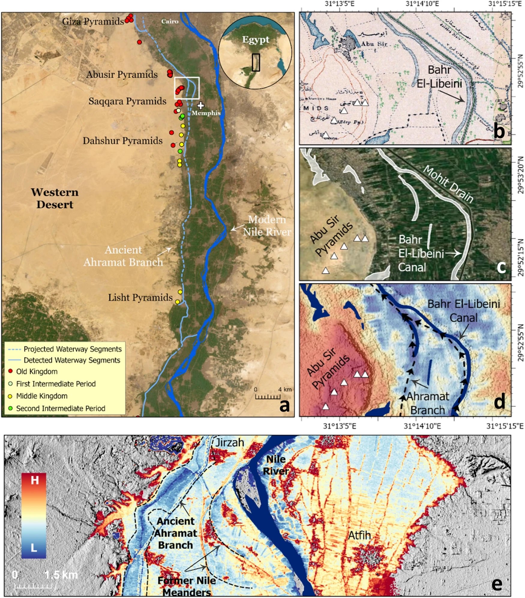
A groundbreaking study, published in the journal Communications Earth & Environment, has revealed why the largest concentration of pyramids in Egypt were built along a narrow desert strip.
Since the beginning of the Pharaonic era, the Nile River has played a fundamental role in the rapid growth and expansion of the Egyptian civilisation.
The Nile provided sustenance and functioned as the primary mode of transportation for goods and building materials, which explains why most of the main cities of the Egyptian civilisation were built in close proximity to the banks of the Nile and its peripheral branches.
Over the centuries, the primary channel of the Nile shifted laterally, causing these peripheral branches to silt up. As a result, population centres were cut off from the vital resources the river provided.
Image Credit : Eman Ghoneim et al
This is apparent with the pyramids along the Western Desert Plateau, where a majority of the pyramids are concentrated along a narrow desert strip several kilometres from the current primary channel of the Nile.
Using a combination of radar satellite imagery, geophysical data, and deep soil coring, the study has investigated the subsurface structure and sedimentology in the Nile Valley adjacent to the pyramid clusters.
This has revealed an extinct branch of the primary channel called the Ahramat Branch, which was connected to the pyramids of the Old and Middle Kingdoms via causeways and their Valley Temples.
According to the study authors: “The Ahramat Branch played a role in the monuments’ construction and was simultaneously active and used as a transportation waterway for workmen and building materials to the pyramids’ sites.”
The eastward migration and abandonment of the Ahramat Branch could be attributed to gradual movement of the river to the lower-lying adjacent floodplain or tilting of the Nile floodplain toward the northeast as a result of tectonic activity, as well as windblown sand incursion due to the branch’s proximity to the Western Desert Plateau.
Header Image Credit : Eman Ghoneim et al
Sources : Ghoneim, E., Ralph, T.J., Onstine, S. et al. The Egyptian pyramid chain was built along the now abandoned Ahramat Nile Branch. Commun Earth Environ 5, 233 (2024). https://doi.org/10.1038/s43247-024-01379-7
This content was originally published on www.heritagedaily.com – © 2023 – HeritageDaily
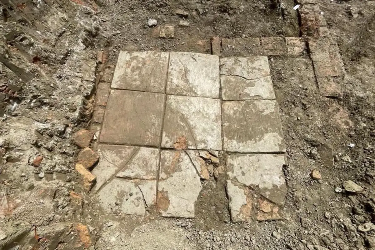
Archaeologists from the National Institute of Cultural Heritage have uncovered a Roman villa with an indoor plunge pool during excavations at the port city of Durrës, Albania.
During antiquity, Durrës was founded by Ancient Greek colonists from Corinth and Corcyra.
The colony emerged into a major trading centre, which during the Roman period was annexed into the expanding territory of the Roman Republic following the conclusion of the Illyrian Wars.
By the 4th century, the city (named Dyrrachium), emerged as the capital of the Roman province of Epirus nova, covering the region of Ancient Epirus.
Image Credit : IKTK
Archaeologists excavating a former residential part of the ancient city have uncovered a high status Roman villa that dates from between the 1st and 4th century AD.
The villa interior contains an indoor pool, richly decorated with frescoes on the walls and mosaic flooring with tiles and inlays of marble, stone, glass and ceramics. Located adjacent to the pool are shallow square basins lined with waterproof mortar, believed to be the remains of an ancient water feature.
Within the northern area of the excavation site, archaeologists found a large brick floor from a thermae, a Roman bath, and further traces of walls from the wider complex.
In the western area, the team discovered fragments of relief stucco that was used to decorate the walls and ceilings of the villa. The reliefs depict anthropomorphic and floral motifs, further indicating the wealth of the villa inhabitants.
According to the archaeologists, the villa was destroyed by an earthquake in the 4th century, corresponding with ancient sources that describe a powerful earthquake causing buildings to collapse and the city defences to crumble.
Header Image Credit : IKTK
Sources : National Institute of Cultural Heritage
This content was originally published on www.heritagedaily.com – © 2023 – HeritageDaily
-
 Ghosts2 years ago
Zozo: The Ouija Board Demon
-
 Space2 years ago
Scientists claim to have found the answer what existed before the Universe
-
 Ghosts2 years ago
Old Coot of Mount Greylock
-
Archaeology1 year ago
New discoveries at Ekʼ Balam during conservation works
-
 General3 years ago
UC San Francisco engaging in horrifying experiments, organ harvesting of live babies in the name of “science”