
Archaeology
Circular shaped Iron Age village found in the Côtes d’Armor
A team of archaeologists have uncovered a circular shaped Iron Age village in the Côtes d’Armor using advanced satellite imaging technology.
The discovery was made using light detection and ranging (LiDAR), a method of remote sensing with light in the form of a pulsed lasers to measure ranges (variable distances) to the Earth.
The differences in the laser return times and wavelength measurements can be used to compile a 3D digital map of the landscape and remove obscuring features.
Using a LiDAR system developed by INRAE (National Institute for e-realistic Archaeological Research), archaeologists have discovered traces of a Gallic village at Cap d’Erquy on the coast of the Côtes d’Armor, France.
The village was inhabited by the Gauls, an Iron Age people that emerged around the 5th century BC in Gallia (encompassing present-day France). The Gauls comprised numerous tribes (known as toutās), many of which constructed extensive fortified settlements called oppida (such as Bibracte) and issued their own coinage.
Gaul never experienced unity under a sole ruler or centralized government. However, the Gallic tribes demonstrated the ability to unite their forces for large-scale military campaigns. The Romans conquered Gaul under the command of Julius Caesar during the Gallic Wars (58–50 BC).
According to a press statement by the Côtes d’Armor Departmental Council, archaeologists have found traces of around twenty roundhouses which were surrounded by a circular defensive rampart. Initial estimates suggest that the village was inhabited between the 8th and 5th centuries BC.
“This is an exceptional discovery which allows us to better understand the daily life of the Gauls during the Iron Age. This technology opens the way to major new discoveries and makes it possible to explore archaeological sites inaccessible through traditional excavations,” said Jean-Yves Peskebrel, archaeologist at INRAE.
Header Image Credit : INRAE
Sources : Côtes d’Armor Departmental Council
This content was originally published on www.heritagedaily.com – © 2023 – HeritageDaily
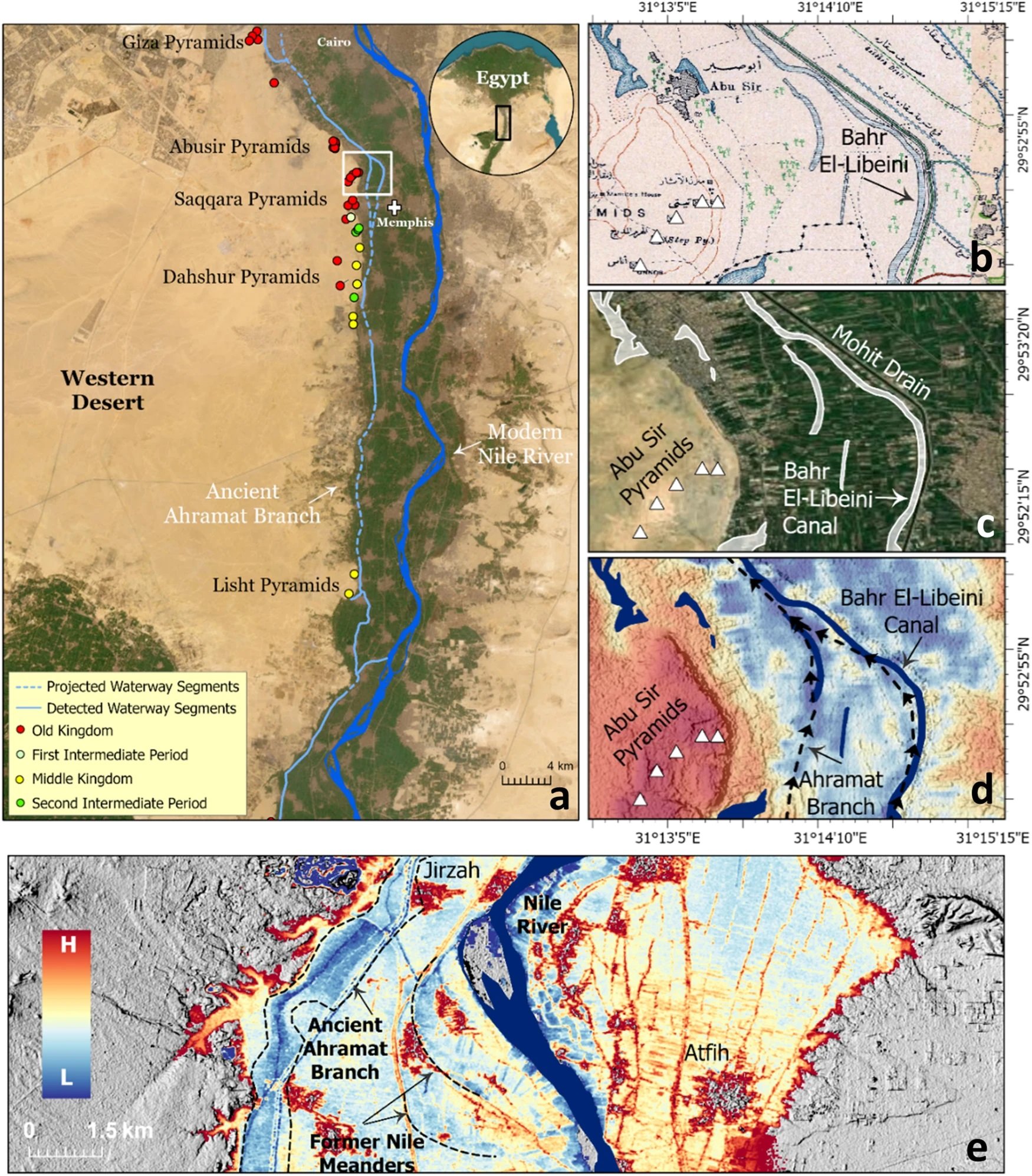
A groundbreaking study, published in the journal Communications Earth & Environment, has revealed why the largest concentration of pyramids in Egypt were built along a narrow desert strip.
Since the beginning of the Pharaonic era, the Nile River has played a fundamental role in the rapid growth and expansion of the Egyptian civilisation.
The Nile provided sustenance and functioned as the primary mode of transportation for goods and building materials, which explains why most of the main cities of the Egyptian civilisation were built in close proximity to the banks of the Nile and its peripheral branches.
Over the centuries, the primary channel of the Nile shifted laterally, causing these peripheral branches to silt up. As a result, population centres were cut off from the vital resources the river provided.
Image Credit : Eman Ghoneim et al
This is apparent with the pyramids along the Western Desert Plateau, where a majority of the pyramids are concentrated along a narrow desert strip several kilometres from the current primary channel of the Nile.
Using a combination of radar satellite imagery, geophysical data, and deep soil coring, the study has investigated the subsurface structure and sedimentology in the Nile Valley adjacent to the pyramid clusters.
This has revealed an extinct branch of the primary channel called the Ahramat Branch, which was connected to the pyramids of the Old and Middle Kingdoms via causeways and their Valley Temples.
According to the study authors: “The Ahramat Branch played a role in the monuments’ construction and was simultaneously active and used as a transportation waterway for workmen and building materials to the pyramids’ sites.”
The eastward migration and abandonment of the Ahramat Branch could be attributed to gradual movement of the river to the lower-lying adjacent floodplain or tilting of the Nile floodplain toward the northeast as a result of tectonic activity, as well as windblown sand incursion due to the branch’s proximity to the Western Desert Plateau.
Header Image Credit : Eman Ghoneim et al
Sources : Ghoneim, E., Ralph, T.J., Onstine, S. et al. The Egyptian pyramid chain was built along the now abandoned Ahramat Nile Branch. Commun Earth Environ 5, 233 (2024). https://doi.org/10.1038/s43247-024-01379-7
This content was originally published on www.heritagedaily.com – © 2023 – HeritageDaily
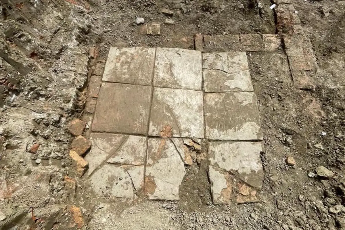
Archaeologists from the National Institute of Cultural Heritage have uncovered a Roman villa with an indoor plunge pool during excavations at the port city of Durrës, Albania.
During antiquity, Durrës was founded by Ancient Greek colonists from Corinth and Corcyra.
The colony emerged into a major trading centre, which during the Roman period was annexed into the expanding territory of the Roman Republic following the conclusion of the Illyrian Wars.
By the 4th century, the city (named Dyrrachium), emerged as the capital of the Roman province of Epirus nova, covering the region of Ancient Epirus.
Image Credit : IKTK
Archaeologists excavating a former residential part of the ancient city have uncovered a high status Roman villa that dates from between the 1st and 4th century AD.
The villa interior contains an indoor pool, richly decorated with frescoes on the walls and mosaic flooring with tiles and inlays of marble, stone, glass and ceramics. Located adjacent to the pool are shallow square basins lined with waterproof mortar, believed to be the remains of an ancient water feature.
Within the northern area of the excavation site, archaeologists found a large brick floor from a thermae, a Roman bath, and further traces of walls from the wider complex.
In the western area, the team discovered fragments of relief stucco that was used to decorate the walls and ceilings of the villa. The reliefs depict anthropomorphic and floral motifs, further indicating the wealth of the villa inhabitants.
According to the archaeologists, the villa was destroyed by an earthquake in the 4th century, corresponding with ancient sources that describe a powerful earthquake causing buildings to collapse and the city defences to crumble.
Header Image Credit : IKTK
Sources : National Institute of Cultural Heritage
This content was originally published on www.heritagedaily.com – © 2023 – HeritageDaily
-
 Ghosts2 years ago
Zozo: The Ouija Board Demon
-
 Space2 years ago
Scientists claim to have found the answer what existed before the Universe
-
 Ghosts2 years ago
Old Coot of Mount Greylock
-
Archaeology1 year ago
New discoveries at Ekʼ Balam during conservation works
-
 General3 years ago
UC San Francisco engaging in horrifying experiments, organ harvesting of live babies in the name of “science”