
Archaeology
Greenland’s Paradise Valley
The Qinngua Valley, also known as Paradisdalen (meaning “paradise valley”) is a unique biome in southern Greenland and contains the island’s only natural forest zone.
The valley runs for 15 kilometres, flanked by snow-capped mountains rising up to 1.6 kilometres above the valley floor. At the northern rocky extent is a freshwater lake that feeds a stream flowing the valley length into Tasersuag Lake due south.
Unlike the rest of Greenland, which has an Arctic tundra climate, Qinngua Valley has conditions that qualify as a micro-sub-arctic climate, with temperatures reaching above 10 °C (50 °F) for at least one, and at most three months of the year.
This unique ecosystem has enabled over 300 species of plants and trees to grow in the valley, however, it is still considered “species poor” due to the isolated position which makes it difficult for plants with heavy seed to invade.
While there are some places in Greenland where man-made forests have been planted, Qinngua Valley is the only undisturbed biome where nature has found a haven from Greenland’s harsh winters.
Species in the valley include: downy birches (Betula pubescens), gray-leaf willows (Salix glauca), and Greenlandic mountain ash (Sorbus groenlandica), which can grow to heights of up to 7-8 metres.
There is speculation that the lower valleys in Greenland’s southern fjords might have once harboured comparable ecosystems to the Qinngua Valley. However, these ecosystems were likely cleared by Norse settlements, who felled trees for construction and fuel, and allowed their sheep and goats to graze freely.
Previous investigations by archaeologists around the Qinngua Valley area have uncovered remnants of a Norse settlement, including traces of residential structures and livestock pens and byres, situated at the top of Eiríksfjörðr (Tunulliarfik fjord).
An analysis of the pollen assemblage zone suggests that occupation of the site spanned from approximately AD 1020 to 1380. Moreover, the pollen data reveals a decline in birch tree and shrub pollen, accompanied by a slight rise in grass pollen, indicating a reduction in woodland area and an expansion of grasslands during this period.
Some scholars argue that this settlement was actually Brattahlíð, Erik the Red’s estate, but this has since been identified to be the located at Qassiarsuk at the head of the Tunulliarfik Fjord.
Header Image Credit : Alamy – Viktor Posnov
Sources : Edwards, Kevin J., J. Edward Schofield, and Jette Arneborg. “Was Erik the Red’s Brattahlið Located at Qinngua? A Dissenting View.” Viking and Medieval Scandinavia 6 (2010): 83–99. Web. | Department of Geosciences and Natural Resource Management – The Forest Plantations in The Greenlandic Arboretum.
This content was originally published on www.heritagedaily.com – © 2023 – HeritageDaily
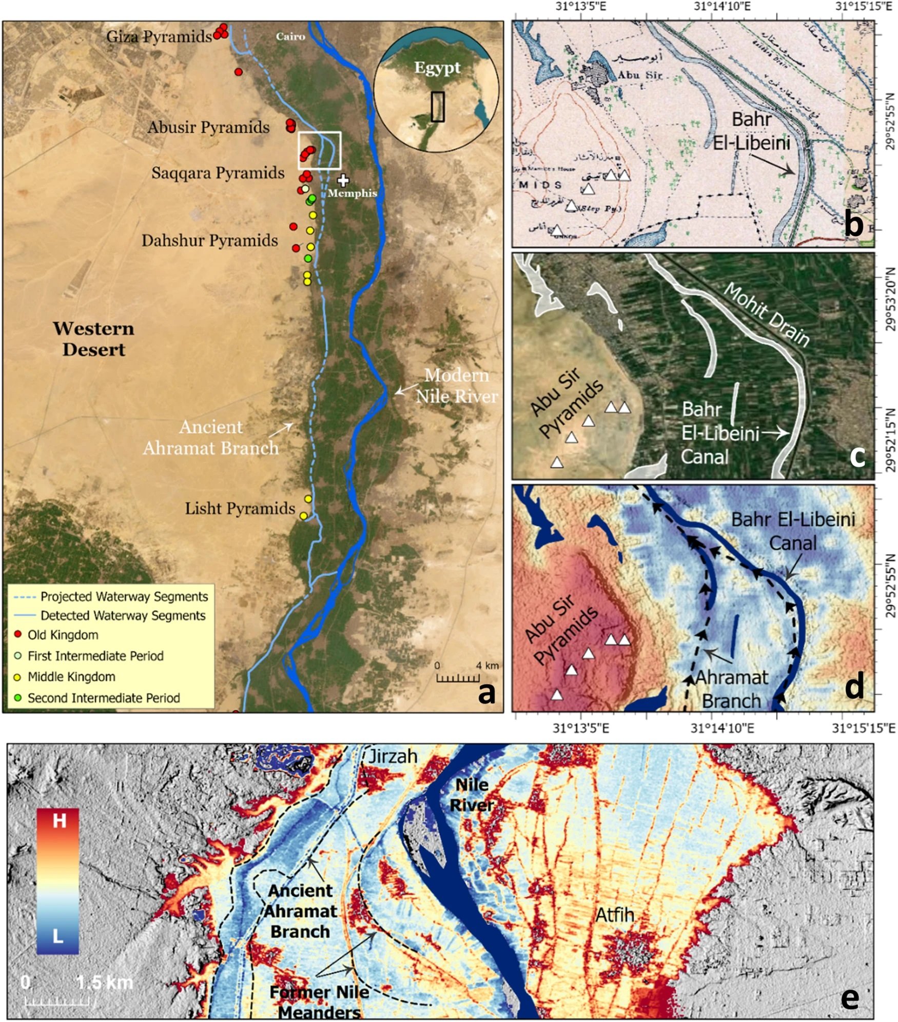
A groundbreaking study, published in the journal Communications Earth & Environment, has revealed why the largest concentration of pyramids in Egypt were built along a narrow desert strip.
Since the beginning of the Pharaonic era, the Nile River has played a fundamental role in the rapid growth and expansion of the Egyptian civilisation.
The Nile provided sustenance and functioned as the primary mode of transportation for goods and building materials, which explains why most of the main cities of the Egyptian civilisation were built in close proximity to the banks of the Nile and its peripheral branches.
Over the centuries, the primary channel of the Nile shifted laterally, causing these peripheral branches to silt up. As a result, population centres were cut off from the vital resources the river provided.
Image Credit : Eman Ghoneim et al
This is apparent with the pyramids along the Western Desert Plateau, where a majority of the pyramids are concentrated along a narrow desert strip several kilometres from the current primary channel of the Nile.
Using a combination of radar satellite imagery, geophysical data, and deep soil coring, the study has investigated the subsurface structure and sedimentology in the Nile Valley adjacent to the pyramid clusters.
This has revealed an extinct branch of the primary channel called the Ahramat Branch, which was connected to the pyramids of the Old and Middle Kingdoms via causeways and their Valley Temples.
According to the study authors: “The Ahramat Branch played a role in the monuments’ construction and was simultaneously active and used as a transportation waterway for workmen and building materials to the pyramids’ sites.”
The eastward migration and abandonment of the Ahramat Branch could be attributed to gradual movement of the river to the lower-lying adjacent floodplain or tilting of the Nile floodplain toward the northeast as a result of tectonic activity, as well as windblown sand incursion due to the branch’s proximity to the Western Desert Plateau.
Header Image Credit : Eman Ghoneim et al
Sources : Ghoneim, E., Ralph, T.J., Onstine, S. et al. The Egyptian pyramid chain was built along the now abandoned Ahramat Nile Branch. Commun Earth Environ 5, 233 (2024). https://doi.org/10.1038/s43247-024-01379-7
This content was originally published on www.heritagedaily.com – © 2023 – HeritageDaily
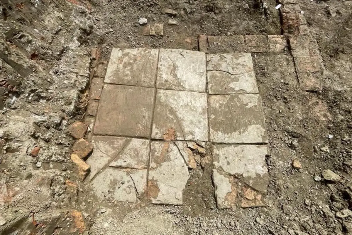
Archaeologists from the National Institute of Cultural Heritage have uncovered a Roman villa with an indoor plunge pool during excavations at the port city of Durrës, Albania.
During antiquity, Durrës was founded by Ancient Greek colonists from Corinth and Corcyra.
The colony emerged into a major trading centre, which during the Roman period was annexed into the expanding territory of the Roman Republic following the conclusion of the Illyrian Wars.
By the 4th century, the city (named Dyrrachium), emerged as the capital of the Roman province of Epirus nova, covering the region of Ancient Epirus.
Image Credit : IKTK
Archaeologists excavating a former residential part of the ancient city have uncovered a high status Roman villa that dates from between the 1st and 4th century AD.
The villa interior contains an indoor pool, richly decorated with frescoes on the walls and mosaic flooring with tiles and inlays of marble, stone, glass and ceramics. Located adjacent to the pool are shallow square basins lined with waterproof mortar, believed to be the remains of an ancient water feature.
Within the northern area of the excavation site, archaeologists found a large brick floor from a thermae, a Roman bath, and further traces of walls from the wider complex.
In the western area, the team discovered fragments of relief stucco that was used to decorate the walls and ceilings of the villa. The reliefs depict anthropomorphic and floral motifs, further indicating the wealth of the villa inhabitants.
According to the archaeologists, the villa was destroyed by an earthquake in the 4th century, corresponding with ancient sources that describe a powerful earthquake causing buildings to collapse and the city defences to crumble.
Header Image Credit : IKTK
Sources : National Institute of Cultural Heritage
This content was originally published on www.heritagedaily.com – © 2023 – HeritageDaily
-
 Ghosts2 years ago
Zozo: The Ouija Board Demon
-
 Space2 years ago
Scientists claim to have found the answer what existed before the Universe
-
 Ghosts2 years ago
Old Coot of Mount Greylock
-
Archaeology1 year ago
New discoveries at Ekʼ Balam during conservation works
-
 General3 years ago
UC San Francisco engaging in horrifying experiments, organ harvesting of live babies in the name of “science”