
Archaeology
Archaeologists search for King John’s lost treasure
Archaeologists from the West Norfolk and King’s Lynn Archaeological Society (WNKLAS) are conducting a search for King John’s lost treasure.
John was born in 1166 at Beaumont Palace in Oxford, England, and was the youngest son of Henry II and Eleanor of Aquitaine.
He ascended to the throne in 1199, however, his turbulent reign has led to John being described as “one of the worst kings ever to rule England”.
The ensuing wars with Philip II of France led to a growing tension between John and his barons, resulting in a resistance movement emerging in the north and east of England.
The barons renounced their feudal ties and marched on London, Lincoln, and Exeter, forcing John to negotiate a peace settlement at Runnymed (which would later become known as Magna Carta).
John failed to honour the terms of Magna Carta and begun raising an army of mercenaries. The barons responded by offering the crown to Prince Louis of France and eventually forced John into retreat.
While John was crossing the tidal estuaries that empty into the Wash on the east coast, it is said that his baggage train containing the English Crown Jewels was swallowed up by quicksand and whirlpools.
A new study by archaeologists from the West Norfolk and King’s Lynn Archaeological Society (WNKLAS) are now hoping to uncover John’s lost treasures in Norfolk.
The researchers will be excavating an area of land next to Walpole Marsh in the Fenlands, located 8 km’s from the present-day coastline. During the Medieval period, the region was a large natural marshland often prone to flooding.
According to the researchers, the excavation site was chosen based on an aerial survey using LiDAR, a method of remote sensing using light in the form of a pulsed laser to measure ranges (variable distances) to the Earth.
Clive Bond, chairman of the West Norfolk and King’s Lynn Archaeological Society (WNKLAS), said: “It’s an opportunity to take a glimpse into the landscape. When you’re looking at something this big it’s quite exciting.”
“There could be something there, absolutely, but actually getting to where it’s been deposited in a changing, dynamic river system – you’re looking a million to one”, added Mr Bond.
Enso Energy is planning to develop the site in late 2024 into a new solar farm to power 10,150 homes. However, according to a report by Enso Energy, “there are no statutory landscape, heritage or ecological designations on site”.
In 1216, John contracted dysentery and died in October at Newark Castle in Nottinghamshire. He was buried in Worcester Cathedral in front of the altar of St Wulfstan.
Header Image Credit : Shutterstock
Sources : West Norfolk and King’s Lynn Archaeological Society (WNKLAS)
This content was originally published on www.heritagedaily.com – © 2023 – HeritageDaily
Archaeologists from Oxford Archaeology have uncovered a well-preserved Bronze Age wooden well in Oxfordshire, England.
The discovery was made during construction works for the Benson Relief Road in compliance with planning conditions to ensure archaeological finds are recorded.
John Boothroyd, Senior Project Manager at Oxford Archaeology, said: “When investigating what appeared to be a standard pit for the site, the archaeological team started exposing the remains of a preserved wooden post driven vertically into the ground.”
Excavations revealed that the posts formed the uprights of a wattle structure lining the edge of the pit, which have been well-preserved due to the soil conditions being waterlogged.
The timber structure was digitally recorded, before being carefully dismantled by hand for removal to the Oxfordshire Museum Service.
Samples of the preserved wood have been sent for further analysis to indicate the type of wood used in the construction. Excavations also found pieces of struck flint, animal bone and pottery used for storage and waste.
Previous studies of the area around Benson and as far as Wallingford have revealed traces of Bronze Age activity and settlement.
“Despite the extremely challenging conditions, the team were able to expose and fully record the well. The specialist soil samples collected will also help establish what the surrounding landscape would have been like, and the intensity to which it was settled, when the well was actively being used.”
Councillor Judy Roberts, Oxfordshire County Council’s Cabinet Member for Infrastructure and Development Strategy, said: “This find gives fantastic insight into the area’s past land use. It is thought the well may have been used for agricultural irrigation purposes for settlements nearby. Archaeological surveys like this are an important part of the process of delivering construction schemes. They help us identify and understand past residents of the area and record them for future generations.”
Header Image Credit : Oxford Archaeology
Sources : Oxfordshire County Council
This content was originally published on www.heritagedaily.com – © 2023 – HeritageDaily
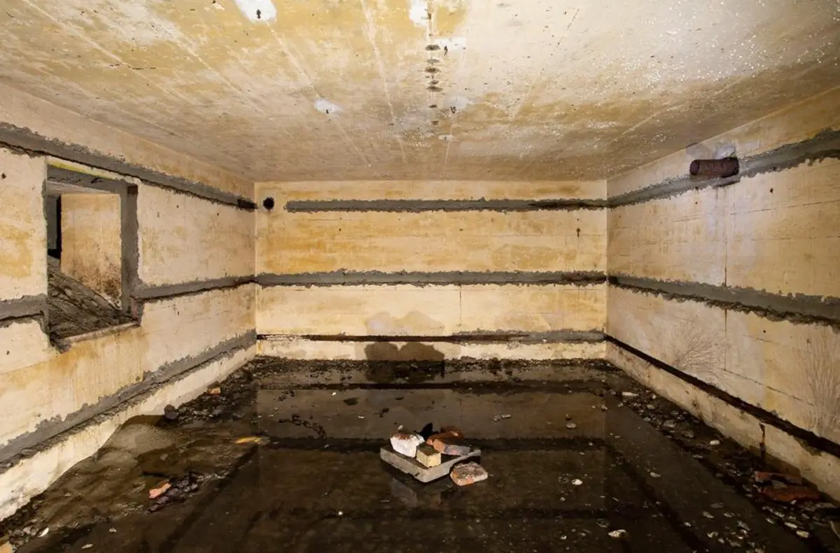
A restoration project to remove invasive plants from dunes in the Heist Willemspark, Belgium, has led to the discovery of three intact WWII bunkers.
Heist Willemspark is located in the Knokke-Heist municipality, situated on the coastline of Belgium near the border with the Netherlands.
During WWI, the area of the park was used as a German position for heavy artillery batteries known as “Freya” and “Augusta”, and a series of forward observation bunkers for ranging shipping in the English Channel.
A number of these structures were repurposed by the German army in WWII, and further fortified as part of the Atlantic Wall, a system of coastal defences built between 1942 and 1944 along the coast of continental Europe. The area of the Atlantic Wall at Heist Willemspark was designated by the German army as Stützpunkt Heyst.
Image Credit : Municipality of Knokke-Heist
According to a press statement by the Municipality of Knokke-Heist, the bunkers were discovered by the Agency for Nature and Forests during a restoration project called LIFE DUNIAS.
Excavations at a depth of only a few feet revealed three Gruppenunterstand Type VF2a bunkers. The VF2a is intended for housing a Gruppe (the smallest German unit consisting of 10 soldiers) who operated forward radar positions. The bunkers at Heist Willemspark measure 6 by 7 metres externally, and are capped by a concrete reinforced roof measuring 1 metre thick.
The project also found traces of brick trenches, a fragment of a concrete track, and large amounts of rubble containing objects such as utensils, ammunition, cabling, and water pipes.
A representative of LIFE DUNIAS said: “These ruins illustrate the previous attempts to completely erase the park’s war history. The lighter structures were demolished and reduced to rubble, while heavier bunkers were covered with a layer of soil and hidden, as if they had never existed.”
Header Image Credit : Municipality of Knokke-Heist
Sources : Municipality of Knokke-Heist
This content was originally published on www.heritagedaily.com – © 2023 – HeritageDaily
-
 Ghosts2 years ago
Zozo: The Ouija Board Demon
-
 Space2 years ago
Scientists claim to have found the answer what existed before the Universe
-
 Ghosts2 years ago
Old Coot of Mount Greylock
-
Archaeology1 year ago
New discoveries at Ekʼ Balam during conservation works
-
 General3 years ago
UC San Francisco engaging in horrifying experiments, organ harvesting of live babies in the name of “science”