
Archaeology
1930’s British railway carriage found buried in Antwerp
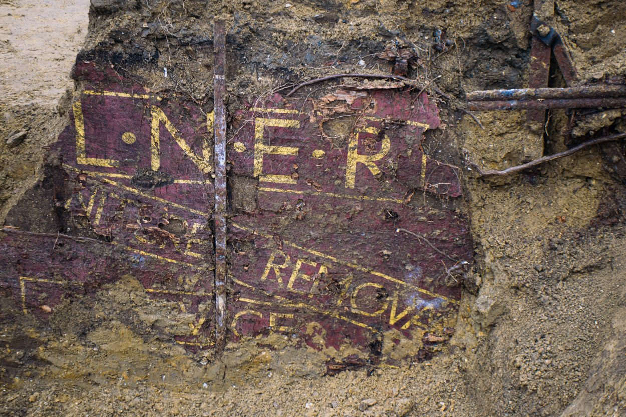
Archaeologists from the city of Antwerp, Belgium, have uncovered a 1930’s British railway carriage during excavations for the Oosterweel Link.
The carriage was found buried along the future route of the Oosterweel Link, part of the greater R1 Antwerp Ring Road being constructed.
According to a press statement by the Oosterweel verbinding, the carriage is stock from LNER – London North Eastern Railway, one of the Big Four railway companies which operated between 1923 and 1948.
The LNER covered the areas north and east of London, and also included the East Coast Mainline from London to Edinburgh, and the routes from Edinburgh to Aberdeen and Inverness.
The company was nationalised in 1948 along with the other Big Four to form British Railways. It continued to exist as a legal entity until it was formally wound up in 1949.
The carriage is painted in red oxide, a colour mainly used around 1930 before it was phased out for the characteristic Oxford blue livery. On the sides are inscriptions reading “”…NITURE REMOVAL TO HOUSE”, “Enquire at any station”, “BK 1820”, and “LNER”.
Image Credit : Oosterweel verbinding
BK 1820 indicates that the carriage is a Container Conflat BK 1820 which was a special wooden decked conflat wagon used for furniture removal, although some were built with insulation for refrigerated use.
Many of the BK 1820 stock were previously cattle trucks, but were converted into container conflats following a downturn in livestock traffic.
Speaking to HeritageDaily, a representative from Oosterweel verbinding, said: “It remains a mystery how the train carriage ended up in Antwerp and why it was buried. It may have been used as a storage space when the North Castle [site of a 19th century fortress] became a recreational spot.”
Header Image Credit : Oosterweel verbinding
Sources : Oosterweel verbinding
This content was originally published on www.heritagedaily.com – © 2023 – HeritageDaily
Researchers from the Life on the Edge project, a collaboration between the University of Bradford and the University of Split, has revealed a lost submerged landscape off the coast of Croatia using underwater scans.
Using state-of-the-art underwater 3D seismic sensors, the researchers have identified a network of ancient streams, rivers, hills, and geological features in the Adriatic Sea off the coast of Split, the second-largest city in Croatia.
Between 10,000 and 24,000 years ago, the sea levels were around 100 metres lower than present day, meaning vast areas of the Adriatic Sea were likely inhabited by people during the Mesolithic period.
Even today, parts of the North Adriatic basin rarely exceeds a depth of 100 metres, while the stretch of water between Venice and Trieste – towards a line connecting Ancona and Zadar, is only 15 metres deep.
Principal investigator Dr Simon Fitch, said: “It’s a more diverse landscape and it’s better preserved than we expected. There are beautifully preserved rivers and estuaries buried beneath what is now the seafloor.”
These features are often indications of where ancient humans lived, as Mesolithic people lived in temporary camps along rivers and lakes for the natural resources.
Vedran Barbarić, Associate professor, from the Faculty of Humanities and Social Sciences of the University of Split, said: “I am certain that the project results will become a landmark in our knowledge on dramatic environmental changes and the human reaction in this part of the world.”
“We have the potential now to begin asking some really fascinating questions, to understanding the archaeology and the culture – in a much more holistic way. Our ultimate goal is to find human artefacts,” added Barbarić.
The team plans to send divers down to several of the identified sites in the hope of finding evidence of human activity.
Header Image Credit : Submerged Landscape Research Centre
Sources : University of Bradford
This content was originally published on www.heritagedaily.com – © 2023 – HeritageDaily
A geophysical study by archaeologists from the Higashi Nippon International University, Tohoku University, and the National Research Institute of Astronomy and Geophysics (NRIAG), have detected an L-shaped structure and several anomalies near the Giza Pyramids using geophysics.
Archaeologists detected the structure using a combination of ground-penetrating radar (GPR) and electrical resistivity tomography (ERT) during a survey of the Western Cemetery.
The Western Cemetery, also known as the Giza West Field, is located on the Giza Plateau to the west of the Great Pyramid of Giza. It is divided into smaller cemeteries, consisting of linear alignments of mastabas and subsurface structures.
Mastabas served as a burial structure for the royal family and high-class officers, characterised by its flat roof and rectangular design constructed using limestone or mudbricks. Central to its construction is a vertical shaft that links to an underground chamber.
According to the researchers, the L-shaped structure was located at a depth of 2 metres directly south from mastaba G4000. The structure appears to have been filled with sand and may have served as an entrance tunnel to a deeper structure.
This is supported by the detection of deeper anomalies beneath the L-shaped structure, concentrated at a depth of 3.5 to 5 metres, with two features persisting down to a depth of 11 metres.
According to a paper published in the journal Archaeological Prospection: “The data show clear anomalies that could be attributed to an archaeological potentiality (high-resistivity contour spots) at the surveyed region. The features have shown a further extension, up to 3–5 m more than the depth screened by the GPR survey. We conclude from these results that the structure causing the anomalies could be vertical walls of limestone or shafts leading to a tomb structure.”
“We believe that the continuity of the shallow structure and the deep large structure is important. From the survey results, we cannot determine the material causing the anomaly, but it may be a large subsurface archaeological structure,” said the study authors.
Header Image Credit : Archaeological Prospection
Sources : GPR and ERT Exploration in the Western Cemetery in Giza, Egypt. https://doi.org/10.1002/arp.1940
This content was originally published on www.heritagedaily.com – © 2023 – HeritageDaily
-
 Ghosts2 years ago
Zozo: The Ouija Board Demon
-
 Space2 years ago
Scientists claim to have found the answer what existed before the Universe
-
 Ghosts2 years ago
Old Coot of Mount Greylock
-
Archaeology1 year ago
New discoveries at Ekʼ Balam during conservation works
-
 General3 years ago
UC San Francisco engaging in horrifying experiments, organ harvesting of live babies in the name of “science”