
Archaeology
Archaeologists to excavate Sheffield Castle where Mary, Queen of Scots was imprisoned
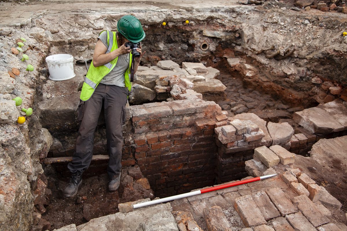
Archaeologists from Wessex Archaeology will be conducting an excavation of Sheffield Castle in Sheffield, England.
Sheffield Castle was constructed following the Norman Conquest of England (1066) at the confluence of the River Sheaf and the River Don.
The earliest known reference of the castle dates from 1188 in a text made by Ralph Murdac, sheriff of Derbyshire, concerning the wardship of Maud de Lovetot.
Of all the guests to stay at Sheffield Castle, the most notable was Mary, Queen of Scots, who was held prisoner within the castle and grounds at various periods between 1570 and 1584.
During the English Civil War, Parliamentarian forces besieged the castle, ultimately reducing it to rubble. No drawings or plans of the castle are known to have survived.
Image Credit : Wessex Archaeology
Throughout April and May of 2024, archaeologists from Wessex Archaeology will be conducting a series of excavations to uncover and preserve the foundations of the circular towers of the castle’s gatehouse, and explore the destruction deposits from the razing of the original motte and bailey castle by John D’Eyvill in the 13th century.
The team will also be investigating areas never before excavated, finally reaching the remains of the 11th to 17th-century castle where Mary Queen of Scots was imprisoned.
Ashley Tuck, the archaeologist leading the dig on behalf of Wessex Archaeology, said: “Once a commanding centre of power for more than 600 years, the castle was left as a ruin by the Parliamentarians at the end of the Civil War as a symbol of its defeat.”
“Since then, the remains of this once-dominating structure have lain hidden from public view. As someone who lives and works in Sheffield, it is a great honour to lead the team uncovering its remains, so we can learn more about its tumultuous history and allow it to once again take centre stage in the city,” added Tuck.
Throughout April and May 2024, the Sheffield community is invited to experience and discover the site’s archaeology firsthand, through open days and opportunities to participate in the excavation for a day. Attendance is FREE with booking required. For more information and to book, visit www.wessexarch.co.uk/events
Header Image Credit : Wessex Archaeology
Sources : Wessex Archaeology
This content was originally published on www.heritagedaily.com – © 2023 – HeritageDaily
Researchers from the Life on the Edge project, a collaboration between the University of Bradford and the University of Split, has revealed a lost submerged landscape off the coast of Croatia using underwater scans.
Using state-of-the-art underwater 3D seismic sensors, the researchers have identified a network of ancient streams, rivers, hills, and geological features in the Adriatic Sea off the coast of Split, the second-largest city in Croatia.
Between 10,000 and 24,000 years ago, the sea levels were around 100 metres lower than present day, meaning vast areas of the Adriatic Sea were likely inhabited by people during the Mesolithic period.
Even today, parts of the North Adriatic basin rarely exceeds a depth of 100 metres, while the stretch of water between Venice and Trieste – towards a line connecting Ancona and Zadar, is only 15 metres deep.
Principal investigator Dr Simon Fitch, said: “It’s a more diverse landscape and it’s better preserved than we expected. There are beautifully preserved rivers and estuaries buried beneath what is now the seafloor.”
These features are often indications of where ancient humans lived, as Mesolithic people lived in temporary camps along rivers and lakes for the natural resources.
Vedran Barbarić, Associate professor, from the Faculty of Humanities and Social Sciences of the University of Split, said: “I am certain that the project results will become a landmark in our knowledge on dramatic environmental changes and the human reaction in this part of the world.”
“We have the potential now to begin asking some really fascinating questions, to understanding the archaeology and the culture – in a much more holistic way. Our ultimate goal is to find human artefacts,” added Barbarić.
The team plans to send divers down to several of the identified sites in the hope of finding evidence of human activity.
Header Image Credit : Submerged Landscape Research Centre
Sources : University of Bradford
This content was originally published on www.heritagedaily.com – © 2023 – HeritageDaily
A geophysical study by archaeologists from the Higashi Nippon International University, Tohoku University, and the National Research Institute of Astronomy and Geophysics (NRIAG), have detected an L-shaped structure and several anomalies near the Giza Pyramids using geophysics.
Archaeologists detected the structure using a combination of ground-penetrating radar (GPR) and electrical resistivity tomography (ERT) during a survey of the Western Cemetery.
The Western Cemetery, also known as the Giza West Field, is located on the Giza Plateau to the west of the Great Pyramid of Giza. It is divided into smaller cemeteries, consisting of linear alignments of mastabas and subsurface structures.
Mastabas served as a burial structure for the royal family and high-class officers, characterised by its flat roof and rectangular design constructed using limestone or mudbricks. Central to its construction is a vertical shaft that links to an underground chamber.
According to the researchers, the L-shaped structure was located at a depth of 2 metres directly south from mastaba G4000. The structure appears to have been filled with sand and may have served as an entrance tunnel to a deeper structure.
This is supported by the detection of deeper anomalies beneath the L-shaped structure, concentrated at a depth of 3.5 to 5 metres, with two features persisting down to a depth of 11 metres.
According to a paper published in the journal Archaeological Prospection: “The data show clear anomalies that could be attributed to an archaeological potentiality (high-resistivity contour spots) at the surveyed region. The features have shown a further extension, up to 3–5 m more than the depth screened by the GPR survey. We conclude from these results that the structure causing the anomalies could be vertical walls of limestone or shafts leading to a tomb structure.”
“We believe that the continuity of the shallow structure and the deep large structure is important. From the survey results, we cannot determine the material causing the anomaly, but it may be a large subsurface archaeological structure,” said the study authors.
Header Image Credit : Archaeological Prospection
Sources : GPR and ERT Exploration in the Western Cemetery in Giza, Egypt. https://doi.org/10.1002/arp.1940
This content was originally published on www.heritagedaily.com – © 2023 – HeritageDaily
-
 Ghosts2 years ago
Zozo: The Ouija Board Demon
-
 Space2 years ago
Scientists claim to have found the answer what existed before the Universe
-
 Ghosts2 years ago
Old Coot of Mount Greylock
-
Archaeology1 year ago
New discoveries at Ekʼ Balam during conservation works
-
 General3 years ago
UC San Francisco engaging in horrifying experiments, organ harvesting of live babies in the name of “science”