
Archaeology
970-metre-long prehistoric megastructure found submerged in Baltic Sea
Geologists have discovered a 970-metre-long megastructure of linear arranged stones, located at a depth of 21 metres on the seabed of Mecklenburg Bight in the Baltic Sea.
The megastructure consists of approximately 1,500 stones and large boulders, which was constructed around 11,000-years-ago during the early Mesolithic period.
According to a study published in the Proceedings of the National Academy of Sciences (PNAS), the megastructure was built by Stone Age hunter-gatherers for hunting herds of the Eurasian reindeer (Rangifer tarandus), which migrated seasonally through the sparsely vegetated post-glacial landscape.
Similar constructions, which are known as drive lanes, are used for manipulating the movement direction of the animals so that they can be easily trapped in a bottleneck and killed. In the example at Mecklenburg Bight, this bottleneck would be between the adjacent lakeshore and the wall, or even into the lake.
Marcel Bradtmöller from the University of Rostock, said: Excluding natural processes and a modern origin, the stonewall could only have been formed after the end of the last ice age, when the landscape was not yet flooded by the Baltic Sea.”
“At this time, the entire population across northern Europe was likely below 5,000 people. One of their main food sources were herds of reindeer, which migrated seasonally through the sparsely vegetated post-glacial landscape,” added Bradtmöller.
According to the researchers, the discovery holds immense scientific significance, being not only the oldest known human structure found in the Baltic Sea, but also for providing new insights into the subsistence patterns of early hunter-gatherer communities.
A further study of the stonewall and the seabed will involve using side-scan sonar, sediment echo sounder, and multibeam echo sounder devices. In addition, underwater archaeologists from the University of Rostock and archaeologists from the LAKD M-V, are scheduled to explore the stonewall and its environs in search of archaeological artefacts that could aid in further understanding the structure’s significance.
Header Image Credit : P. Hoy, 3D Model : J. Auer
This content was originally published on www.heritagedaily.com – © 2023 – HeritageDaily
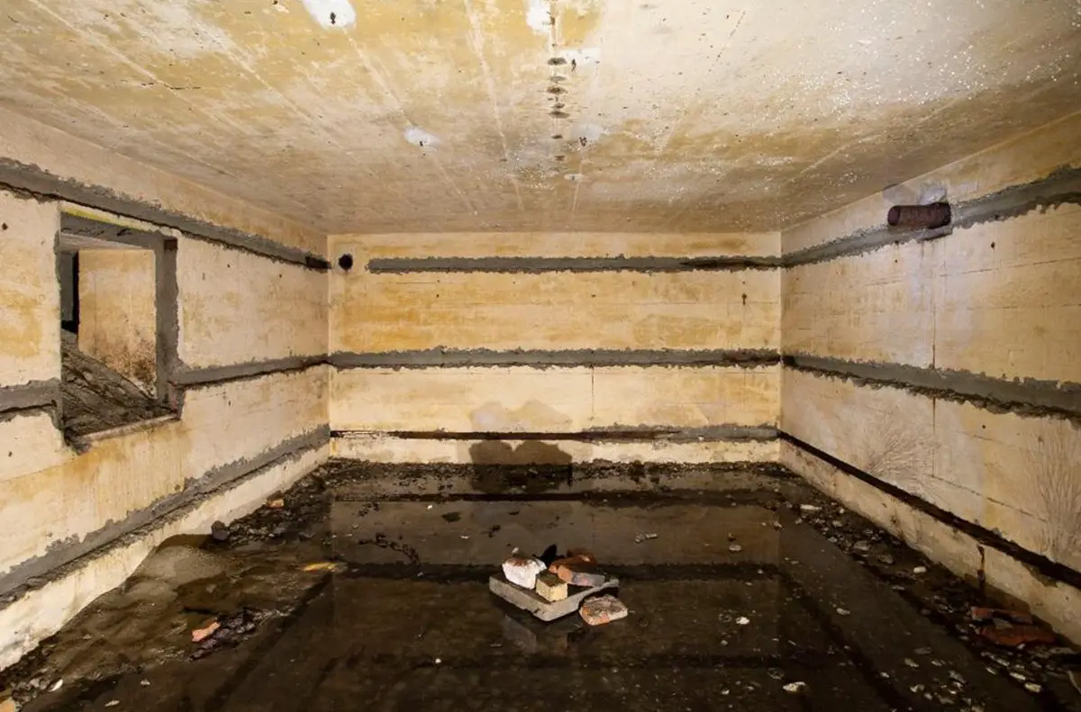
A restoration project to remove invasive plants from dunes in the Heist Willemspark, Belgium, has led to the discovery of three intact WWII bunkers.
Heist Willemspark is located in the Knokke-Heist municipality, situated on the coastline of Belgium near the border with the Netherlands.
During WWI, the area of the park was used as a German position for heavy artillery batteries known as “Freya” and “Augusta”, and a series of forward observation bunkers for ranging shipping in the English Channel.
A number of these structures were repurposed by the German army in WWII, and further fortified as part of the Atlantic Wall, a system of coastal defences built between 1942 and 1944 along the coast of continental Europe. The area of the Atlantic Wall at Heist Willemspark was designated by the German army as Stützpunkt Heyst.
Image Credit : Municipality of Knokke-Heist
According to a press statement by the Municipality of Knokke-Heist, the bunkers were discovered by the Agency for Nature and Forests during a restoration project called LIFE DUNIAS.
Excavations at a depth of only a few feet revealed three Gruppenunterstand Type VF2a bunkers. The VF2a is intended for housing a Gruppe (the smallest German unit consisting of 10 soldiers) who operated forward radar positions. The bunkers at Heist Willemspark measure 6 by 7 metres externally, and are capped by a concrete reinforced roof measuring 1 metre thick.
The project also found traces of brick trenches, a fragment of a concrete track, and large amounts of rubble containing objects such as utensils, ammunition, cabling, and water pipes.
A representative of LIFE DUNIAS said: “These ruins illustrate the previous attempts to completely erase the park’s war history. The lighter structures were demolished and reduced to rubble, while heavier bunkers were covered with a layer of soil and hidden, as if they had never existed.”
Header Image Credit : Municipality of Knokke-Heist
Sources : Municipality of Knokke-Heist
This content was originally published on www.heritagedaily.com – © 2023 – HeritageDaily
Ongoing excavations by archaeologists from The First Colony Foundation have revealed new findings on the historical narrative of the “Lost Colony” of Roanoke.
The Roanoke Colony refers to two colonisation attempts in North America by Sir Walter Raleigh during the 16th century.
Raleigh’s aim was to stake England’s claim to the largely unknown (to Europeans) landmass of North America, and from which he could launch raids on the Spanish West Indies and annual treasure fleets.
The first attempt was made in 1585 on Roanoke Island, located in present-day Dare County, North Carolina.
According to accounts by the returning expedition leaders, the colonists had established friendly relations with the indigenous people (the Secotan), describing the land as “pleasant and bountiful.”
In reality, the colony was troubled by a lack of supplies and poor relations with the Native Americans, resulting in the colony being abandoned in 1586.
A second attempt was made in 1587 in the area of Chesapeake Bay, however, upon returning to the colony in 1590, it was found fortified with a palisade and that the settlers had vanished without a trace.
The search for what happened to the English settlers has recently focused on the Elizabethan Gardens in the town of Manteo, where archaeologists have uncovered evidence of a farmstead belonging to the “Algonquian village of Roanoke” (also spelled Roanoac), an Indigenous community that hosted the settlers in 1584.
Excavations in March 2024 have uncovered shards of Algonquian pottery dating back to the 1500s, along with a ring of copper wire (made of drawn copper) likely worn by an Algonquian warrior.
Archaeologists speculate that the ring was brought to North America by the English settlers and traded with the indigenous people who believed that copper had spiritual significance.
“Finding domestic pottery—the type used for cooking—in close proximity to an apparent piece of Native American jewellery strongly confirms we are digging in the midst of a settlement,” said Dr. Eric Klingelhofer, the First Colony Foundation’s Vice President of Research. “And Roanoac is the only known village at that site. The copper ring indicates contact with the English,” added Klingelhofer.
Previous excavations suggest that the village had a palisade with around nine internal houses for the elite warrior class. Those of a lower status or working class lived outside the palisade on farmsteads where they worked the land raising crops.
“The new findings confirm a theory that matches what we know of the village,” added Klingelhofer. “It was described as a palisaded village because the explorers came here and recorded it. And these findings add to our story.”
Another exploration is scheduled for the summer of 2024 at nearby Fort Raleigh National Historic Site. The goal is to find evidence of the colonists’ original settlement.
Header Image Credit : John Parker Davis – Public Domain
Sources : The First Colony Foundation
This content was originally published on www.heritagedaily.com – © 2023 – HeritageDaily
-
 Ghosts2 years ago
Zozo: The Ouija Board Demon
-
 Space2 years ago
Scientists claim to have found the answer what existed before the Universe
-
 Ghosts2 years ago
Old Coot of Mount Greylock
-
Archaeology1 year ago
New discoveries at Ekʼ Balam during conservation works
-
 General3 years ago
UC San Francisco engaging in horrifying experiments, organ harvesting of live babies in the name of “science”