
Archaeology
Clay jar points to connection between Israel under the Reign of King Solomon and the Kingdom of Sheba
Archaeologists from the Institute of Archaeology of the Hebrew University of Jerusalem have deciphered a Sabaean inscription on a clay jar, pointing to a connection between Israel under the Reign of King Solomon and the Kingdom of Sheba.
According to the Hebrew Bible and the Old Testament, Solomon, also called Jedidiah, was the penultimate ruler of an amalgamated Israel and Judah sometime around 970 to 931 BC. The Bible says that Solomon dedicated the First Temple in Jerusalem to Yahweh, or God in Judaism, and is depicted as a wealthy, wise, and powerful figure, as well as one of the 48 Jewish prophets.
In 2012, archaeologists conducting excavations in the Ophel area south of the Temple Mount, uncovered a large jar inscribed with text written in Canaanite script, from which the ancient Hebrew script used during the time of the First Temple derives.
Only seven letters from the inscription survive, which according to a new study published in the Hebrew University’s Jerusalem Journal of Archaeology, is actually “Ancient South Arabian,” the script that was used in the south-west part of the Arabian Peninsula (the Yemen region of today), where the Kingdom of Sheba was the dominant kingdom at the time.
The Kingdom of Sheba was the home of the biblical “Queen of Sheba”, a figure first mentioned in the Hebrew Bible. In the original story, she brings a caravan of valuable gifts for Solomon, however, her existence is disputed by academics. Modern historians identify Sheba with the South Arabian kingdom of Saba in present-day Yemen and Ethiopia, while competing theories places the kingdom in South Arabia or the Horn of Africa.
According to the study, the inscription on the jar reads: , “[ ]shy l’dn 5,” means five “ šǝḥēlet,” referring to one of the four ingredients mentioned in the Bible (Exodus 30:34) required for the incense mixture. The “šǝḥēlet” was an essential ingredient in the incense that was burnt in the First and Second Temples and was called “tziporen” in Rabbinic literature.
The researchers suggest that this indicates a connection between Jerusalem of the 10th century BC (during the reign of Solomon) and the Kingdom of Sheba. The jar was manufactured in or near Jerusalem, and the inscription suggests a speaker of Sabaean who was involved in supplying the incense spices.
Dr. Vainstub, from the Hebrew University of Jerusalem, said: “Deciphering the inscription on the jar teaches us not only about the presence of a speaker of Sabaean in Israel during the time of King Solomon, but also about the system of geopolitical relations in our region at the time – especially in light of the place where the jar was discovered, an area known for also being the administrative centre during the days of King Solomon. This is another testament to the extensive trade and cultural ties that existed between Israel under King Solomon and the Kingdom of Sheba.”
Hebrew University of Jerusalem
Header Image Credit : Shani Jaffe
A recent study, published in the journal ResearchGate, proposes that the Pyramid of Djoser could have been constructed using hydraulic lift.
The Pyramid of Djoser, also known as the Step Pyramid, is a proto-pyramid built as the final resting place of Djoser, the first or second pharaoh of Egypt’s 3rd Dynasty (2670–2650 BC) during the Old Kingdom period.
The pyramid rises from the Saqqara plateau in six steps to a height of around 60 to 62 metres, serving as the centre of a vast mortuary complex.
Due to the absence of authentic sources from the pyramid architects’ working sphere, there is currently no confirmed comprehensive model for the method used in the pyramid construction.
The prevailing theory suggests that the heavy stone blocks were transported on apparatuses such as rollers, and raised to height using a series of ramps.
In the study, a survey of watersheds near to the pyramid indicate that the Gisr el-Mudir (enclosure) has features of a check dam for trapping sediment and water. Furthermore, the topography beyond the “dam” shows a possible ephemeral lake west of the Djoser complex, and water flow inside the moat surrounding it.
The study authors explain: “In the southern section of the moat, we show that the monumental linear rock-cut structure consisting of successive, deep compartments, combines the technical requirements of a water treatment facility: a settling basin, a retention basin, and a purification system.”
Based on this finding, the study proposes that the Gisr el-Mudir and moat’s inner south section worked as a unified hydraulic system for regulating flow and improving water quality. In addition, the pyramid’s internal architecture is consistent with a hydraulic elevation mechanism never reported before.
“The ancient architects likely raised the stones from the pyramid centre in a volcano fashion using the sediment-free water from the Dry Moat’s south section. Ancient Egyptians are famous for their pioneering and mastery of hydraulics through canals for irrigation purposes and barges to transport huge stones. This work opens a new line of research: the use of hydraulic force to erect the massive structures built by Pharaohs,” said the study authors.
Please note: This study was submitted to PLOS ONE on December 7, 2023. After two rounds of review by peers, the paper was formally accepted by PLOS ONE on June 27, 2024. Since July 23, 2024, it has been the subject of new consultations and review by the PLOS ONE Editorial Board.
Header Image Credit : Shutterstock
Sources : ResearchGate | Piton, Guillaume. (2024). On the possible use of hydraulic force to assist with building the Step Pyramid of Saqqara. PLOS ONE.
This content was originally published on www.heritagedaily.com – © 2023 – HeritageDaily
Constructed between 1630 and 1633 in a Renaissance-Baroque style, the Great Synagogue of Vilnius served as the religious centre of a complex of synagogues, mikvahs, and community institutions devoted to Torah study in Vilnius, Lithuania.
According to a press statement by the Israel Antiquities Authority (IAA): “The Great Synagogue of Vilna was the beating heart of the Lithuanian Jewry, which included 12 synagogues and study houses, the community council building, the home of Rabbi Eliyahu – the Vilna Gaon, Kosher meat stalls, the famous ‘Strashun’ library, a bathhouse and more.”
During World War II, the synagogue was looted, burned, and partially destroyed by the Nazis in the holocaust. Soviet authorities completely demolished the remaining structure to build a school, intending to prevent any future restoration of Jewish worship.
Only three original pieces of the synagogue survived the destruction: a door of the Holy Ark, a reader’s desk, and a bas-relief with the Ten Commandments, which are now on display at the Vilna Gaon Jewish Museum.
Image Credit : Israel Antiquities Authority
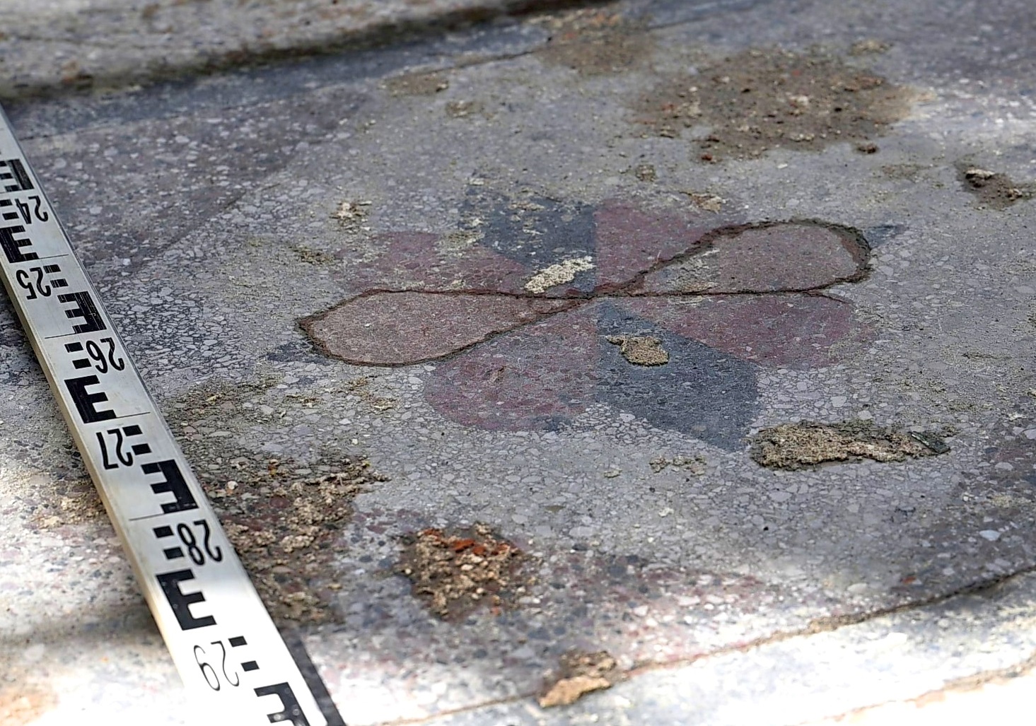
In a recent study conducted by the IAA, the Association of Lithuanian Archaeology, the Good Will Foundation, and the Jewish Community of Lithuania, archaeologists have rediscovered traces of the synagogue’s decorated walls and remnants of flooring with red, black, and white floral patterns that paved the main hall.
Excavations also uncovered huge water reservoirs to feed halachically pure water to the mikva’ot, and one of the giant pillars that surrounded the Bimah (prayer platform).
Dr. Jon Seligman from the IAA and Justinas Rakas from the Lithuanian Archaeological Society, said: “The magnificent remains we are rediscovering bring back moments in the life of a lost vibrant community.”
Header Image Credit : Israel Antiquities Authority
Sources : IAA
This content was originally published on www.heritagedaily.com – © 2023 – HeritageDaily
-
 Ghosts2 years ago
Zozo: The Ouija Board Demon
-
 Space2 years ago
Scientists claim to have found the answer what existed before the Universe
-
 Ghosts2 years ago
Old Coot of Mount Greylock
-
Archaeology1 year ago
New discoveries at Ekʼ Balam during conservation works
-
 General3 years ago
UC San Francisco engaging in horrifying experiments, organ harvesting of live babies in the name of “science”